Minecraft(我的世界)要塞坐标计算器
本程序可以通过您输入的多组末影之眼起落地坐标计算要塞的位置。
This program can calculate the location of the fortress through multiple sets of the landing coordinates of the eye of ender you input.
To read the English version, Please move to the end of the document.
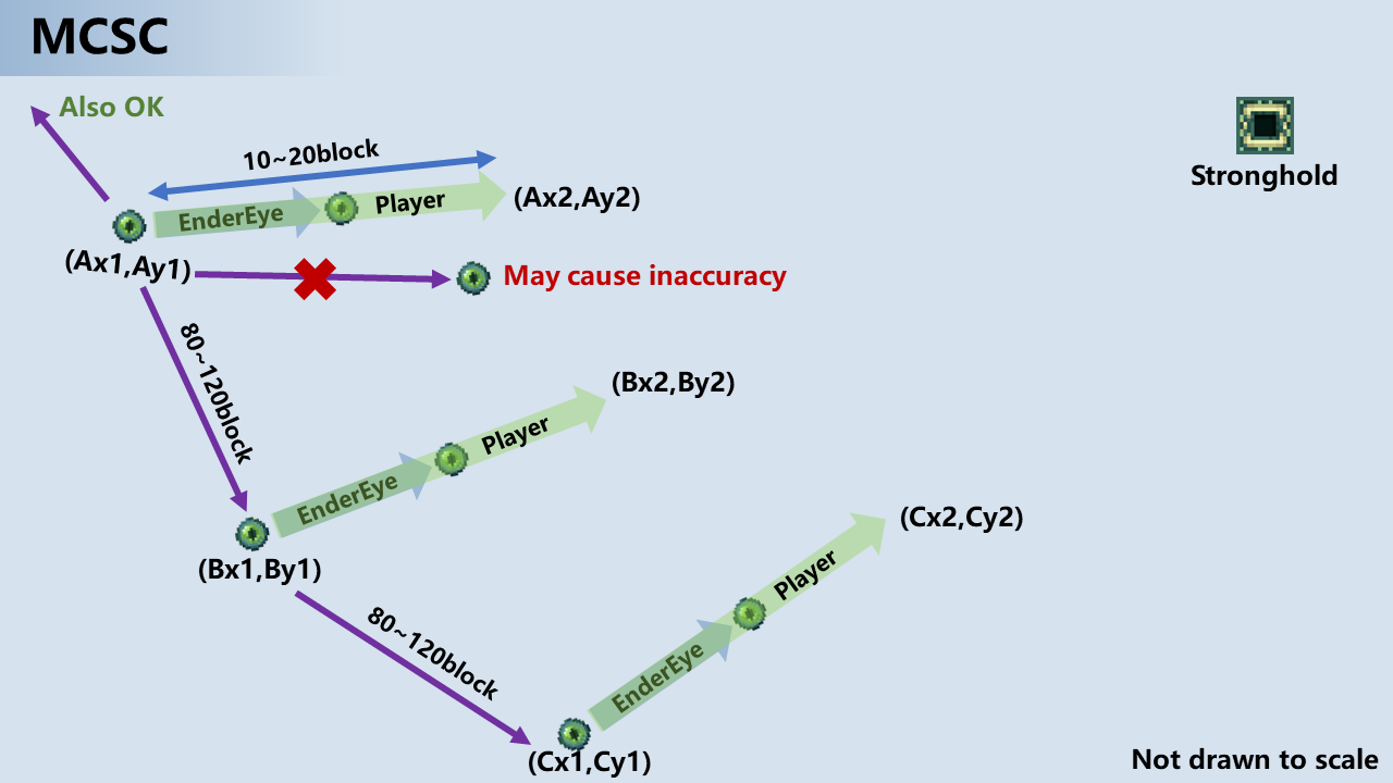
1.准备三个以上末影之眼,并寻找一个空旷的场地
2.打开坐标与准星显示(F3/Fn+F3)
3.记录当前坐标(Ax1,Ay1)
4.在原地抛出末影之眼,将准星y轴(绿色)对准空中的末影之眼并尽量与其保持在一条直线上
5.向正前移动10-20格(需确保未向左或右偏移),记录坐标(Ax2,Ay2)
6.打开程序,点击开始,输入这两组坐标(Ax1,Ay1)和(Ax2,Ay2),点击下一步
7.向左或右移动80-120格(移动方向不要与之前末影水晶飞行方向水平,应有45-120度的角度)
8.重复4-7步骤执行两次,注意所有扔出的末影之眼应指向同一个要塞
9.将数据输入程序
10.三组数据输入完成后,程序会给出误差报告,你可以使用校准来获得一个更精确的数据
10.1.校准时,重复4-7步骤获取另一组数据并输入,如果方法正确,误差应该减小
11.如果您能接受当前误差,点击查看结果,程序将为您计算要塞坐标
以下是操作图例
程序支持多语言,您需要将对应的语言文件(.qm)复制到程序运行目录,封装版本应该自带英语选项。
The program supports multiple languages, you need to copy the corresponding language file (.qm) to the program running directory, and the packaged version should have its own English option.
因为程序UI仅适配简体中文,因此在载入其他语言后,你需要点击按钮来查看某些文本。
Because the program UI only adapts to Simplified Chinese, after loading other languages, you need to click the button to view some text.
以下附上操作说明的英文版本
-
Prepare more than three eyes of ender and look for an open space
-
Turn on the coordinates and crosshair display (F3/Fn+F3)
-
Record the current coordinates (Ax1, Ay1)
-
Throw the eye of ender on the spot, align the y-axis (green) of the front sight with the eye of ender in the air and try to keep it in a straight line with it
-
Move 10-20 squares to the front (make sure not to shift to the left or right), and record the coordinates (Ax2, Ay2)
-
Open the program, click Start, enter these two sets of coordinates (Ax1,Ay1) and (Ax2,Ay2), click Next
-
Move 80-120 grids to the left or right (the movement direction should not be level with the previous flight direction of the end crystal, there should be an angle of 45-120 degrees)
-
Repeat steps 4-7 twice, pay attention to all the thrown eyes of ender should point to the same fortress
-
Enter data into the program
-
After the three sets of data are entered, the program will give an error report. You can use calibration to obtain a more accurate data
10.1. During calibration, repeat steps 4-7 to obtain another set of data and enter it. If the method is correct, the error should be reduced
- If you can accept the current error, click to view the result, the program will calculate the fortress coordinates for you